Distance: 4 miles, RT
Hiking Time: 2 hrs
Elevation Gain: 600 ft
High Point: 7,006 ft
Snow Free: Mid-July - September
GPS Waypoints:
Trailhead: N 46° 54' 57.00", W 121° 38' 37.50"
Dege Peak: N 46° 55' 6.72", W 121° 36' 38.70"
A splendid alpine walk to experience the Sunrise side of Mt. Rainier
For a terrific day in the mountains with exceptional views of Mt. Rainier, you can't beat the Sunrise Visitor's Center as a destination. This is the highest point in the park reachable by car... elevation 6400 ft. This place usually opens in late June and closes in mid-October. Here you find a wonderful interpretive center, a grand view of Mt. Rainier and friendly volunteers to answer any question you may have about the area. There is also a gift shop and restaurant in the original lodge, a picnic area and, best of all, flush toilets!!! You can spend a couple of hours here enjoying the sub-alpine flowers of late July to early August or the bright fall colors of September and October, but the best thing about this area is the variety of trails that start from this parking lot.
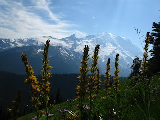
The trail to the right takes you along the ridge past four small peaks in a row, the 4th being Dege Peak. It's the only one of them that has an established trail to the top of it. From the parking lot the hike is just under 2 miles to the peak and relatively easy once you get to the top of Sourdough Ridge. When you get there, you feel like you are on top of the world at 7006 ft. The only thing taller than you for miles is Mt. Rainier.
As you stand there take the time to turn 360 degrees and identify the places around you. Far off in the distance to the south is Mt. Adams. It looks so small in comparison to the majestic peak right in front of you. To the east and below, you will see the Sunrise Point parking lot... an alternative starting point for this hike, with Sunrise Lake and Clover Lake. Off in the distance is Hwy 410 climbing toward Chinook Pass. North of Dege Peak, way off in the distance is Mt. Baker. Northeast of the peak are Grand Park, (the huge, flat, alpine meadow), and Fremont Lookout. As you turn to the west, the large, sandy mountaintops above the visitor's center are the Burroughs Mountains. Many of these places are hiking destinations themselves, reachable in a day, but more difficult. As you complete the circle, Mt. Rainier will hold your gaze forever if you let her. There are so many breathtaking sights on her grand sides that words cannot express her beauty.
This is one of my favorite hikes to take my friends and family on. It's moderately easy and doesn't take the whole day to get there and back. Then you have time to stop at the gift shop and get an ice cream before heading home.
Mary Janosik
Visit Rainier Hiking Expert
For information on visiting Mt. Rainier, go to www.visitrainier.com.
Visit Rainier is a not-for-profit, non-membership destination marketing organization that promotes tourism in the gateway communities around Mt. Rainier.
Connect with Visit Rainier


No comments:
Post a Comment